
TERRY AND LORI’S GREAT ADVENTURE
What better way to deal with the pressure of changing printers for your livelihood than get away for a day or two on a Great Adventure? And that’s just what we did several weeks ago. We combined a Great Adventure we already had taken with a new adventure and, I have to say, the timing was just perfect.
Lori and I had previously visited the Colorado National Monument outside of Grand Junction and wanted to go again. Great news! It’s still there and as awe inspiring as ever. When we went before, we also took in the Peach Festival in Palisade. More good news! The peaches are still there and as delicious as ever.
But this time we added the Grand Mesa Scenic Byway and it gave us another reason to return to the western part of the state.
The Grand Mesa Scenic Byway is 63 miles long and takes about two hours to drive straight through. The byway climbs through the Plateau Creek canyon to cool evergreen forests 11,000 feet above sea level. Emeraldgreen fields carpet this playground in the sky, which offers and abundance of fishing, hiking, and mountain biking. Glistening blankets of snow dress the Grand Mesa in winter for snowshoeing, skiing, and snowmobiling.
In 1996, the byway was designated by the U.S. Secretary of Transportation as a National Scenic Byway. There are 13 American Byways designated in Colorado.
Grand Mesa is the largest, flattopped mountain in the world, spanning 500 square miles and rising between 5,000 and 11,237 feet in elevation.
The top of the mountain is a layer of basalt poured by lava which has protected the mesa from the erosion suffered by surrounding sedimentary rocks.
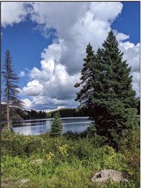
There are over 300 lakes and a few streams. There is an abundance of recreational activities including touring, biking, hiking, camping, fishing, boating, ATV, horseback riding, alpine and Nordic skiing, snowshoeing, snowmobiling, snow biking and dining.
As much as we enjoy hiking, the ride was so beautiful that we just stopped a number of places and took pictures. We only hiked in one area.
We started on the Discovery Trail. It was only a half mile loop at an elevation of about 10,000 feet. It is an interactive trail with a guidebook to go along with it highlighting some of the nature in the area.
Since it was so short, we quickly wandered off the trail and ended up getting an opportunity to explore areas around several of the numerous lakes. There are a total of 41 trails in the area ranging from 32 to 6,440 feet in elevation gain.
One spot you will want to take the time to go to is the Land’s End Overlook, which clings 6,000 feet above the valley and offers views as far away as the La Sals ranges in Utah.
The Land O Lakes are featured hikes that take you to view 18 lakes where you can also see the San Juan Mountains.
Plateau Canyon, at the extreme north end, of the byway feature sandstone canyons. What a great and beautiful adventure.